Every year, our 8th graders go to New York City for their Class Trip. It's a pretty big deal. Some of these kids have never been out of New England.
A few years ago, the teachers and advisors on the trip were tearing their hair out at the jaded attitude of our students. Our guys got off the bus, looked around for a moment or two, then said something like, "Huh! Big buildings. When do we go shopping?"
I don't think the phrase "Aaaaaaaargh!!!!" quite covers this situation.
After we got back from the trip that year, the staff did some brainstorming about our too-cool-for-Manhattan students and what we came up with was this:
Why the heck SHOULD they be impressed? What did they know about New York - its history, culture, art, food, etc..? Was it reasonable to expect them to be impressed by something they had no frame of reference to understand?
So every year since then, my 8th grade team has finished up the school year with a big, over-the-top multi-disciplinary unit on the History, Geography, Poetry and Math of New York City. In Social Studies, I devote several weeks to teaching our 8th graders the geography and history of the city. (What is a borough? What is the difference between Manhattan and New York City? What's the big deal about the Brookyln Bridge - I mean, it's just a BRIDGE, after all...? What really happened on 9-11?) This gives me a useful platform to spiral all the concepts we've been learning about all year long - the Constitution, Electoral Politics, Transportation, Immigration, African-American History and Geography. My collegues in Math and Literacy do similarly intensive things in their disciplines.
The difference in student attitudes has been nothing short of astounding. Our guys get off the bus jumping out of their skin with excitement about seeing all the things they've been learning about. They will lecture anyone who stands still long enough about the history of what we are seeing. A couple of years ago, our students told our tour guide so much about the Triangle Shirtwaist Fire and Manhattan schist that he was under the impression that we were from some private school for geniuses up in the hills of New Hampshire. (We're not.)
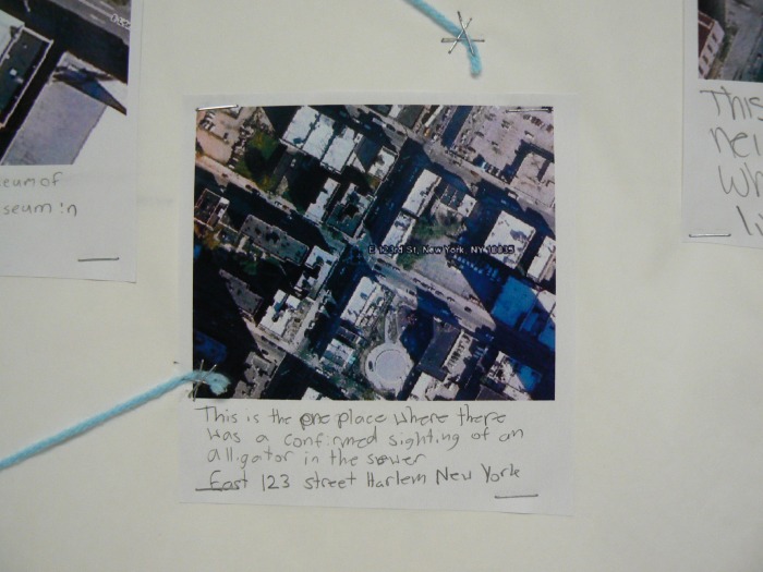
To finish off the New York City unit before we leave, each student has to complete a New York City project. He or she picks a topic from a long list and becomes an expert on that topic - everything from The History of Central Park to The Best Places to Find Junkfood in Manhattan to Are There Really Alligators in the Sewers?
A few years ago, the teachers and advisors on the trip were tearing their hair out at the jaded attitude of our students. Our guys got off the bus, looked around for a moment or two, then said something like, "Huh! Big buildings. When do we go shopping?"
I don't think the phrase "Aaaaaaaargh!!!!" quite covers this situation.
After we got back from the trip that year, the staff did some brainstorming about our too-cool-for-Manhattan students and what we came up with was this:
Why the heck SHOULD they be impressed? What did they know about New York - its history, culture, art, food, etc..? Was it reasonable to expect them to be impressed by something they had no frame of reference to understand?
So every year since then, my 8th grade team has finished up the school year with a big, over-the-top multi-disciplinary unit on the History, Geography, Poetry and Math of New York City. In Social Studies, I devote several weeks to teaching our 8th graders the geography and history of the city. (What is a borough? What is the difference between Manhattan and New York City? What's the big deal about the Brookyln Bridge - I mean, it's just a BRIDGE, after all...? What really happened on 9-11?) This gives me a useful platform to spiral all the concepts we've been learning about all year long - the Constitution, Electoral Politics, Transportation, Immigration, African-American History and Geography. My collegues in Math and Literacy do similarly intensive things in their disciplines.
The difference in student attitudes has been nothing short of astounding. Our guys get off the bus jumping out of their skin with excitement about seeing all the things they've been learning about. They will lecture anyone who stands still long enough about the history of what we are seeing. A couple of years ago, our students told our tour guide so much about the Triangle Shirtwaist Fire and Manhattan schist that he was under the impression that we were from some private school for geniuses up in the hills of New Hampshire. (We're not.)
To finish off the New York City unit before we leave, each student has to complete a New York City project. He or she picks a topic from a long list and becomes an expert on that topic - everything from The History of Central Park to The Best Places to Find Junkfood in Manhattan to Are There Really Alligators in the Sewers?
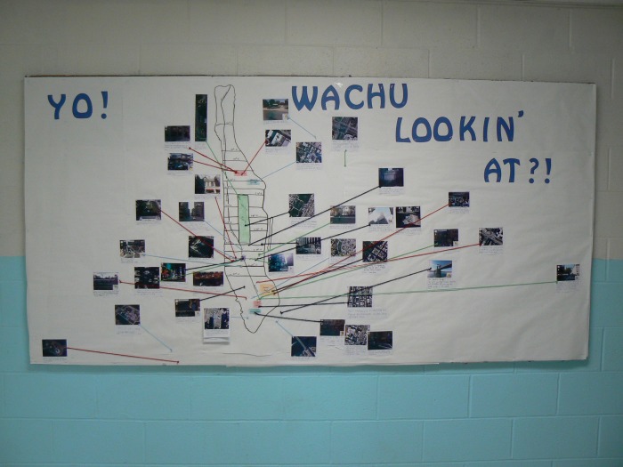
This bulletin board is one way our students display their knowledge.
Each of them uses GoogleMaps Streetview or Google Earth to find a street-level or an aerial view of one of the places they have studied in the course of researching his or her project. Each of them does a screen capture of the view on Google, imports it into a graphics program, resizes it, and saves it to a file for printing. When they get the hard copy of their picture, they write a quick identifying sentence/explanation of the picture, then post it on our bulletin board, which has a map of Manhattan traced on it.
Each of them uses GoogleMaps Streetview or Google Earth to find a street-level or an aerial view of one of the places they have studied in the course of researching his or her project. Each of them does a screen capture of the view on Google, imports it into a graphics program, resizes it, and saves it to a file for printing. When they get the hard copy of their picture, they write a quick identifying sentence/explanation of the picture, then post it on our bulletin board, which has a map of Manhattan traced on it.
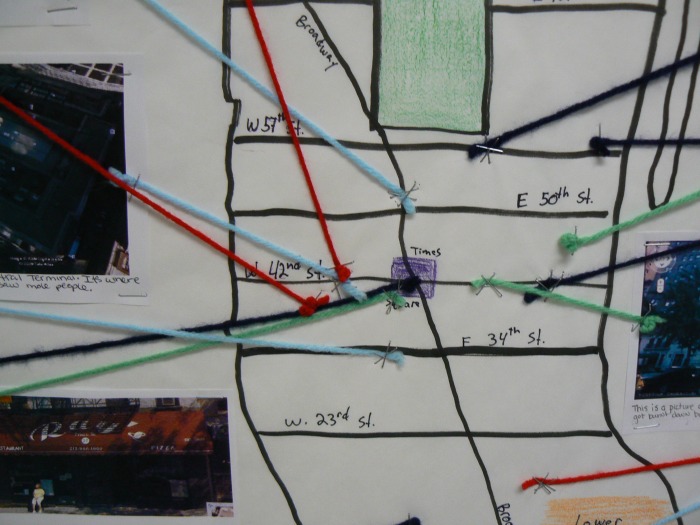
They connect their pictures to the Manhattan map with colored yarn to show where their place is located.
This is an incredibly weird synthesis of high and low tech, but this bulletin board makes a striking visual statement in our hallway. When the material is presented this way, it becomes sort of impressive how much our guys have learned about the topic collectively.
This is an incredibly weird synthesis of high and low tech, but this bulletin board makes a striking visual statement in our hallway. When the material is presented this way, it becomes sort of impressive how much our guys have learned about the topic collectively.
 RSS Feed