
This past week, I found myself teaching an unlikely lesson to our 8th graders - the importance of horse manure in American History. (Surprisingly, it is a HUGE part of our development as a nation.)
Anyway, I was showing a PowerPoint to my students of pictures I had taken a couple of years ago on a photo-tour of Beacon Hill in Boston. I'd noticed that most of the ritzy old houses had bootscrapers mounted on the front steps and knowing that I could use this someday in class, I started taking pictures of each one we came to. At first, the other people on the tour just gave me surprised looks and quizzical smiles, but then after a while, they started to gravitate toward my wife and ask if I had "issues".
I was explaining this to my class when one of my students interupted me and asked, "Oh, you mean like your 'issues' with PowerPoint?"
It's a fair point - I use PowerPoint a LOT in my classroom. I should probably move on and learn newer and better tools, but I'm still getting so much out of this one program that for the forseeable future, I'm afraid I'll look at most classroom computer applications as PowerPoint and Other Stuff.
[I did have a TeacherFeelGood moment last week involving PowerPoints. I was kicking off a new unit with a PowerPoint. A new girl was sitting in the front row and when I announced that we'd have a short PowerPoint, she put her head in her hands in dispair. The boy next to her tapped her on the shoulder and said, "No. It's okay - he's really good!" It made me feel like Mr. Kotter.]
Anyway, I've discovered another cool new PowerPoint trick.
I was directed to a REALLY interesting podcast by a colleague on a Social Studies forum. It discussed the idea of "non-linear PowerPoints" - in other words, slideshows that are not designed to be viewed in any particular order. (A good example of this is the Jeopardy PowerPoint I discussed in the previous post.)
The ideas they discussed got me thinking about how I use PowerPoint and how useful it might be to help students review for Geography quizzes. I'm a big fan of online mapping games. They are really useful to drive home a geography lesson - if there happens to be a game out there that deals with the particular lesson you've just taught. Unfortunately, for about half of my geography lessons, the places and features that I want my students to memorize are pretty eclectic and aren't the sort of items that you're likely to find on a mapping game.
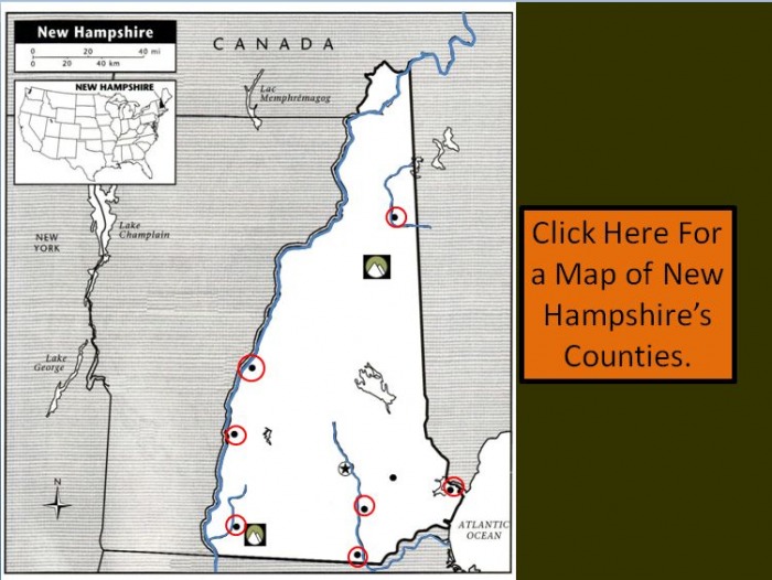
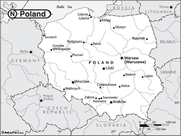
Take my lesson on New Hampshire, for instance.
I ask my students to memorize each of the counties and several cities, rivers, mountains and lakes in New Hampshire. These are good and worthy things for my particular class to know, but let's face it, this is not universally vital knowledge. Nobody is going to put the Ashuelot River on a mapping game designed for wide distribution.
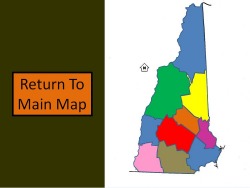
But what if I designed a PowerPoint with a map of New Hampshire and put all those features on the map? I could outline each city, county, feature, etc... with an invisible box, then link each one to a slide that identified it. Svetlana and Bruno, my hypothetical students, would point their cursors to the weird, obscure river in the southwest corner of the state, take their best guess as to what it is, then click it to see the answer. They would jump to the appropriate slide, go, "Ohhhhh... THAT Ashuelot River!" then click another link to take them back to the main map.
They'd be mapping geniuses!
So, does it work? Is it all rainbows and unicorns?
Um. Acutally, yes.
It was actually very easy and even my first interactive studyguide went together in an hour or two. (Future ones should be a little faster.)
There are just a few tricks. Here's what I learned:
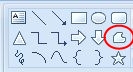
1. Use the FreeForm drawing tool to outline counties, countries, rivers, lakes, etc... It will be easier to do this if you zoom in and view the shape at several hundred percent of its actual size. (See my previous post on outlining for more information.)
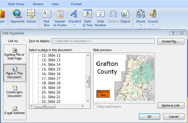
2. When you've outlined the feature you're interested in linking a page to, make sure it's selected, then choose, Insert/Hyperlink/Place In This Document.

3. When highlighting a city (which is too small to make an easily clickable link) or a really irregular shape like Lake Winnepesaukee, outline it with a circle (or a square or a trapezoid, if that's more your style), then format it to be 100% transparent - in other words, invisible. Make sure you do this for the outline and for the fill.
4. Select all the pages, then choose "Animation" and format the transitions between pages so that you can't move on to the next page by time OR by clicking. (Uncheck the boxes.) This means that your students will only be able to navigate by clicking your hyperlinks and not accidentally moving onto the wrong page by hitting the spacebar or anything.
If you want to take a look at my first attempt at interactive, non-linear, hyper-awesome PowerPoints (or if you need a studyguide for New Hampshire), feel free to download it here.
 RSS Feed